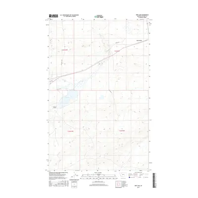
2017 Map of Kipp Lake
USGS Topo · Published 2017About this map
Meriwether serves as a primary reference point in this corner of Glacier County, situated amidst a landscape defined by the drainage of Willow Cr and Flatiron Cr. The terrain is characterized by the distinct landforms of the Great Plains, including the Kittson Coulee and the prominent Kipp Lake to the south. Transportation in this era relies on a network of named local routes that reflect the area's ranching and transit history, such as the Blackfoot Cutoff, Labreches Rd, and Bad Eyes Rd. These roads traverse the township lines of t33n r10w and t33n r9w, illustrating the geometric precision of the Public Land Survey System against the winding natural paths of the local creeks.
Find a feature on this map
13 named features on this map. Tap any name to fly to it.
Don’t see what you’re looking for? This feature index may not catch every label — zoom into the map to look around manually.
Map Details
Editions of this 2017 Kipp Lake Map
This is the sole edition of this map. No revisions or reprints were ever made.
Other maps of this area

1911 · Blackfoot
USGS Topo · 1:125,000

1914 · Heart Butte
USGS Topo · 1:125,000

1918 · Heart Butte
USGS Topo · 1:125,000

1960 · Cut Bank
USGS Topo · 1:250,000

1963 · Cut Bank
USGS Topo · 1:250,000

1964 · Cut Bank
USGS Topo · 1:250,000
1968 · Piegan
USGS Topo · 1:24,000

1968 · Rimrock Butte
USGS Topo · 1:24,000

1968 · White Man Coulee
USGS Topo · 1:24,000
1968 · Magee Ranch
USGS Topo · 1:24,000