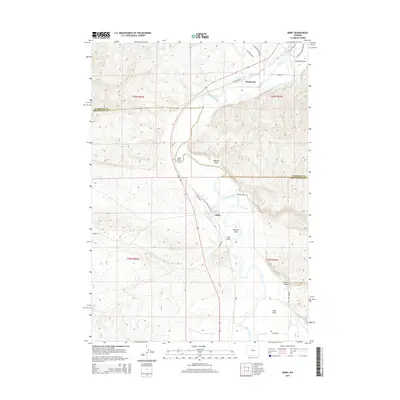
2015 Map of Kirby
USGS Topo · Published 2015About this map
Kirby and Winchester anchor this portion of the Bighorn Basin, where the Bighorn River carves through a landscape defined by significant topographic relief and agricultural engineering. The settlement of Kirby is centrally located, served by Kirby Ditch, while the northern reaches include the Bluff Ditch and the expansive Tie Down Flats. The map reveals a complex network of drainage features, including Sand Draw, Walters Draw, and Coal Draw, which illustrate the natural erosion patterns of the region's arid terrain.
Find a feature on this map
27 named features on this map. Tap any name to fly to it.
Don’t see what you’re looking for? This feature index may not catch every label — zoom into the map to look around manually.
Map Details
Editions of this 2015 Kirby Map
This is the sole edition of this map. No revisions or reprints were ever made.
Other maps of this area

1914 · Blue Mesa
USGS Topo · 1:62,500

1916 · Blue Mesa
USGS Topo · 1:62,500

1945 · Kirby
USGS Topo · 1:62,500

1946 · Kirby
USGS Topo · 1:62,500

1955 · Thermopolis
USGS Topo · 1:250,000

1958 · Thermopolis
USGS Topo · 1:250,000

1960 · Red Hole
USGS Topo · 1:24,000

1960 · Thermopolis
USGS Topo · 1:24,000

1962 · Thermopolis
USGS Topo · 1:250,000
1965 · Rattlesnake Gulch
USGS Topo · 1:24,000