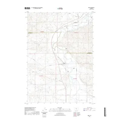
2018 Map of Kirby
USGS Topo · Published 2018About this map
Kirby and Winchester sit along the winding course of the Bighorn River as it passes through the borderlands of Washakie Co and Hot Springs Co. The landscape is a study in Western water management, where engineered irrigation features like Kirby Ditch and Bluff Ditch intersect with the natural drainage of Walters Draw and Sand Draw. For genealogists and local historians, several small burial sites are preserved here, including Gebo Cem, Winchester Cem, and Crosby Cem. These markers, along with Gebo Oil Field Rd and Cowboy Mine Rd, hint at the area's legacy of resource extraction and energy development. The geography transitions from the level Tie Down Flats in the northeast to more complex terrain marked by Freeman Draw and Coal Draw, reflecting the varied topography of this Wyoming river corridor.
Find a feature on this map
32 named features on this map. Tap any name to fly to it.
Don’t see what you’re looking for? This feature index may not catch every label — zoom into the map to look around manually.
Map Details
Editions of this 2018 Kirby Map
This is the sole edition of this map. No revisions or reprints were ever made.
Other maps of this area

1914 · Blue Mesa
USGS Topo · 1:62,500

1916 · Blue Mesa
USGS Topo · 1:62,500

1945 · Kirby
USGS Topo · 1:62,500

1946 · Kirby
USGS Topo · 1:62,500

1955 · Thermopolis
USGS Topo · 1:250,000

1958 · Thermopolis
USGS Topo · 1:250,000

1960 · Red Hole
USGS Topo · 1:24,000

1960 · Thermopolis
USGS Topo · 1:24,000

1962 · Thermopolis
USGS Topo · 1:250,000
1965 · Rattlesnake Gulch
USGS Topo · 1:24,000