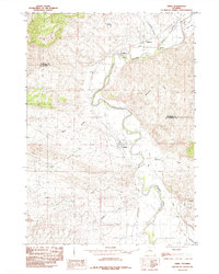
1985 Map of Kirby
USGS Topo · Published 1985About this map
The Bighorn River carves a deep valley through this portion of the Bighorn Basin, where an intricate network of irrigation projects like the Hanover Canal and Kirby Ditch defines the agricultural landscape. Settled along the riverbanks, Kirby and Winchester anchor the valley floor, while the surrounding terrain is marked by dry draws including Walters Draw and Dempsey Draw. The presence of Gebo to the west points to the region's mining history, situated near Coal Draw and Sand Draw.
Find a feature on this map
18 named features on this map. Tap any name to fly to it.
Don’t see what you’re looking for? This feature index may not catch every label — zoom into the map to look around manually.
Map Details
Editions of this 1985 Kirby Map
This is the sole edition of this map. No revisions or reprints were ever made.
Other maps of this area

1914 · Blue Mesa
USGS Topo · 1:62,500

1916 · Blue Mesa
USGS Topo · 1:62,500

1945 · Kirby
USGS Topo · 1:62,500

1946 · Kirby
USGS Topo · 1:62,500

1955 · Thermopolis
USGS Topo · 1:250,000

1958 · Thermopolis
USGS Topo · 1:250,000

1960 · Red Hole
USGS Topo · 1:24,000

1960 · Thermopolis
USGS Topo · 1:24,000

1962 · Thermopolis
USGS Topo · 1:250,000
1965 · Rattlesnake Gulch
USGS Topo · 1:24,000