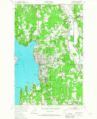
1950 Map of Kirkland
USGS Topo · Published 1967About this map
Lake Washington defines the western edge of this mid-century survey, its shoreline dotted with the developing residential and institutional hubs of Kirkland and Houghton. The landscape is a mix of wooded uplands like Norway Hill and active transit corridors, most notably the Northern Pacific railroad threading through the Sammamish River valley past Redmond. This era shows a community balancing recreation and industry, with several courses including Juanita Golf Course appearing alongside the U S Naval Air Station at Sand Pt. Local infrastructure for a growing population is evident in the numerous educational sites like Central Sch and Collins Sch, while the Fairfax Sanitarium and the sprawling Bridle Trail State Park occupy significant tracts of land before the dense suburbanization of later decades.
Find a feature on this map
40 named features on this map. Tap any name to fly to it.
Don’t see what you’re looking for? This feature index may not catch every label — zoom into the map to look around manually.
Map Details
Editions of this 1950 Kirkland Map
4 editions found

Other maps of this area

1894 · Seattle
USGS Topo · 1:62,500

1895 · Snohomish
USGS Topo · 1:125,000

1897 · Seattle
USGS Topo · 1:125,000

1908 · Seattle
USGS Topo · 1:62,500

1909 · Seattle Special
USGS Topo · 1:62,500

1942 · Edmonds
USGS Topo · 1:62,500

1944 · Everett
USGS Topo · 1:62,500

1949 · Seattle North
USGS Topo · 1:24,000
1949 · Seattle South
USGS Topo · 1:24,000

1950 · Redmond
USGS Topo · 1:24,000