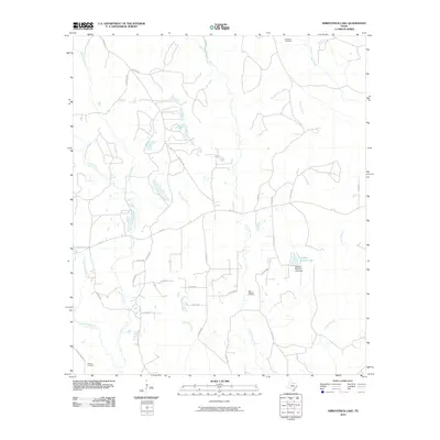
2010 Map of Kirkpatrick Lake
USGS Topo · Published 2010About this map
Theuvenins Creek and its many tributaries, including Thouching Creek and Turkey Creek, dominate this landscape in Tyler County. The presence of the East Hillister Oil Field indicates the localized industrial character of the region during this era, while small rural burial sites like Goalsbee Cemetery and Allison Cemetery provide essential touchpoints for genealogical research. Water management and local recreation are centered around Drakes Branch Lake, featuring the Drakes Branch Lake Dam. The map also traces a dense network of county roads, such as Allison Cemetery Rd and Pope Mill Rd, which connect these water bodies and historical sites. The convergence of numerous branches and creeks, including Big Cypress Creek and Spurlock Branch, creates a complex drainage system that has historically shaped the settlement patterns and land use in this part of East Texas.
Find a feature on this map
39 named features on this map. Tap any name to fly to it.
Don’t see what you’re looking for? This feature index may not catch every label — zoom into the map to look around manually.
Map Details
Editions of this 2010 Kirkpatrick Lake Map
This is the sole edition of this map. No revisions or reprints were ever made.
Other maps of this area

1954 · Beaumont
USGS Topo · 1:250,000

1955 · Woodville
USGS Topo · 1:62,500

1955 · Curtis
USGS Topo · 1:62,500

1957 · Beaumont
USGS Topo · 1:250,000

1958 · Warren
USGS Topo · 1:62,500

1958 · Spurger
USGS Topo · 1:62,500

1984 · Beaumont
USGS Topo · 1:250,000
1984 · Woodville
USGS Topo · 1:24,000
1984 · Town Bluff
USGS Topo · 1:24,000
1984 · Hillister
USGS Topo · 1:24,000