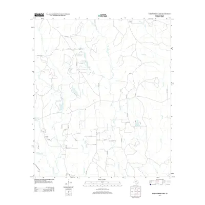
2013 Map of Kirkpatrick Lake
USGS Topo · Published 2013About this map
The East Hillister Oil Field anchors the southern landscape of this Tyler County survey, highlighting the intersection of industrial extraction and the winding watercourses of the East Texas Piney Woods. Significant creek systems including Theuvenins Cr and Turkey Cr dominate the topography, creating a network of drainages that feed into larger bodies like Spurlock Lake and Drakes By Lake. The road network is largely defined by rural county routes and distinctive thoroughfares such as Pope Mill Rd and Koon Tap Rd. For those tracing local heritage, the map identifies established burial sites like Goalsbee Cem in the north and Allison Cem near the southern boundary. The presence of the oil field alongside these traditional landmarks reflects the dual character of the region as both a place of family history and resource production.
Find a feature on this map
45 named features on this map. Tap any name to fly to it.
Don’t see what you’re looking for? This feature index may not catch every label — zoom into the map to look around manually.
Map Details
Editions of this 2013 Kirkpatrick Lake Map
This is the sole edition of this map. No revisions or reprints were ever made.
Other maps of this area

1954 · Beaumont
USGS Topo · 1:250,000

1955 · Woodville
USGS Topo · 1:62,500

1955 · Curtis
USGS Topo · 1:62,500

1957 · Beaumont
USGS Topo · 1:250,000

1958 · Warren
USGS Topo · 1:62,500

1958 · Spurger
USGS Topo · 1:62,500

1984 · Beaumont
USGS Topo · 1:250,000
1984 · Woodville
USGS Topo · 1:24,000
1984 · Town Bluff
USGS Topo · 1:24,000
1984 · Hillister
USGS Topo · 1:24,000