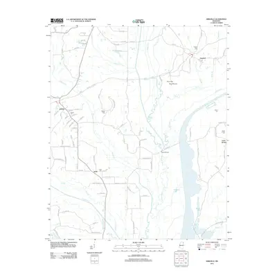
2012 Map of Kirkville
USGS Topo · Published 2012About this map
Pharr Mounds stand as a significant archaeological landmark on Pharr Flats, marking the ancient cultural landscape of Prentiss County near the Natchez Trace Pkwy. This 2012 survey documents the rural character of communities like Kirkville and Sandy Springs, where the topography is defined by the winding course of the Tombigbee River and the expansive Ferguson Lake. The map reveals a high density of burial grounds, including the Pleasant Valley Cem and Gilmore Chapel Cem, which offer essential data for genealogists tracking family roots in this corner of Mississippi. Hydrological features such as Twentymile Cr and Big Brown Cr intersect with a network of county roads, illustrating the persistent importance of local watercourses to the area's layout and historical connectivity at Walkers Bridge.
Find a feature on this map
98 named features on this map. Tap any name to fly to it.
Don’t see what you’re looking for? This feature index may not catch every label — zoom into the map to look around manually.
Map Details
Editions of this 2012 Kirkville Map
This is the sole edition of this map. No revisions or reprints were ever made.
Other maps of this area

1921 · Booneville
USGS Topo · 1:48,000

1921 · Tupelo
USGS Topo · 1:48,000

1922 · Booneville
USGS Topo · 1:62,500

1923 · Tupelo
USGS Topo · 1:62,500

1956 · Tupelo
USGS Topo · 1:250,000

1958 · Tupelo
USGS Topo · 1:250,000

1965 · Mooreville
USGS Topo · 1:24,000
1965 · Paden SE
USGS Topo · 1:24,000

1965 · Fulton SE
USGS Topo · 1:24,000

1965 · Fulton
USGS Topo · 1:24,000