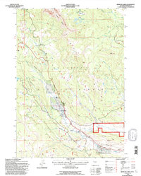
1991 Map of Kisinger Lakes
USGS Topo · Published 1997About this map
The Tie Hack Historical Monument stands as a focal point in this high-altitude landscape within the Shoshone National Forest, marking the region's legacy of timber harvesting for the railroad. The terrain is defined by dramatic elevations, from the jagged Pinnacle Buttes to the alpine Kisinger Lakes. Water dominates the geography, with the Wind River and Sheridan Creek carving through the valleys, while Brooks Lake Creek Falls and various unnamed falls dot the drainage basins. Human presence is concentrated around the Pinnacle Heights Summer Home Group near Brooks Lake, while more utilitarian markers like a First Aid Station and a Gravel Pit reflect the area's use by foresters and seasonal residents. This 1991 revision provides a detailed view of the complex hydrology of the Middle Fork Long Creek and West Fork Long Creek before modern forest management shifts.
Find a feature on this map
30 named features on this map. Tap any name to fly to it.
Don’t see what you’re looking for? This feature index may not catch every label — zoom into the map to look around manually.
Map Details
Editions of this 1991 Kisinger Lakes Map
This is the sole edition of this map. No revisions or reprints were ever made.
Other maps of this area

1902 · Mt Leidy
USGS Topo · 1:125,000

1905 · Younts Peak
USGS Topo · 1:125,000

1907 · Younts Peak
USGS Topo · 1:125,000

1955 · Driggs
USGS Topo · 1:250,000

1955 · Thermopolis
USGS Topo · 1:250,000

1956 · Esmond Park
USGS Topo · 1:24,000

1956 · Shoshone Pass
USGS Topo · 1:24,000

1956 · Warm Spring Mountain
USGS Topo · 1:24,000

1956 · Fish Lake
USGS Topo · 1:24,000

1956 · Kisinger Lakes
USGS Topo · 1:24,000