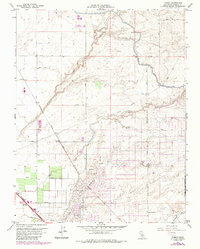
1961 Map of Kismet
USGS Topo · Published 1987About this map
Agricultural development and water management define the landscape north of Madera as documented in this 1961 survey, later updated in the 1980s. The convergence of two major transit lines, the Atchison Topeka and Santa Fe Railroad and the Southern Pacific, anchors the local transport network near Kismet and Notarb. The map illustrates a complex irrigation and drainage system necessary for Central Valley farming, featuring the prominent Madera Canal and natural waterways like Berenda Creek and Dry Creek. Recreational land use is concentrated at the Madera Country Club and the Madera Lake County Park and Rec Area. Cultural landmarks such as a local Racetrack and the Diversion Dam on Schmidt Creek provide insight into the rural economy and community life of the mid-20th century.
Find a feature on this map
27 named features on this map. Tap any name to fly to it.
Don’t see what you’re looking for? This feature index may not catch every label — zoom into the map to look around manually.
Map Details
Editions of this 1961 Kismet Map
4 editions found
Other maps of this area

1912 · Mariposa
USGS Topo · 1:125,000

1916 · Berenda
USGS Topo · 1:31,680

1918 · Berenda
USGS Topo · 1:31,680

1918 · La Grand
USGS Topo · 1:31,680

1919 · Raynor Creek
USGS Topo · 1:31,680

1920 · Kismet
USGS Topo · 1:31,680

1920 · Bonita Ranch
USGS Topo · 1:31,680

1921 · Daulton
USGS Topo · 1:31,680

1921 · Bonita Ranch
USGS Topo · 1:31,680

1922 · Gregg
USGS Topo · 1:31,680