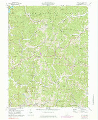
1972 Map of Kitts Hill
USGS Topo · Published 1984About this map
Wayne National Forest and the Vesuvius Recreation Area dominate the northern landscape of this Lawrence County quadrangle. Centered on Kitts Hill, the map reveals a rugged topography defined by the narrow valleys of Storms Creek and Little Ice Creek, where small settlements and family farms once clustered. The inclusion of several rural churches, such as Oakland Chapel and Triedstone Ch, alongside numerous family burial grounds like Fradd Cem and Maddy Cem, provides a detailed record of the community structure during the early 1970s. Industrial activity is subtly present through scattered Mines and a Quarry, while the southern border captures the educational hub at Dawson-Bryant Sch near Deering. The network of pipelines and a telephone line crossing Lodge Ridge indicates the region's role in local utility infrastructure during this era.
Find a feature on this map
73 named features on this map. Tap any name to fly to it.
Don’t see what you’re looking for? This feature index may not catch every label — zoom into the map to look around manually.
Map Details
Editions of this 1972 Kitts Hill Map
Other maps of this area

1892 · Huntington
USGS Topo · 1:125,000

1898 · Huntington
USGS Topo · 1:125,000

1898 · Ironton
USGS Topo · 1:62,500

1900 · Ironton
USGS Topo · 1:62,500

1901 · Guyandot
USGS Topo · 1:62,500

1901 · Ceredo
USGS Topo · 1:62,500

1902 · Guyandot
USGS Topo · 1:62,500

1903 · Kenova
USGS Topo · 1:125,000

1904 · Kenova
USGS Topo · 1:125,000

1906 · Athalia
USGS Topo · 1:62,500