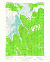
1957 Map of Klamath Marsh
USGS Topo · Published 1962About this map
Klamath Marsh and its complex wetlands dominate this 1957 landscape, where the Williamson River winds through the high desert of south-central Oregon. The map documents a sparsely populated ranching and timber area within the Winema National Forest, featuring isolated outposts like Kittredge Ranch, Summers Ranch, and Johnson Barn. An interesting historical detail is the location of Military Crossing over the marsh, a reminder of early travel routes through the region. Significant terrain features include The Peninsula and Hog Island, which rise from the marshy waters. To the east, the landscape transitions toward Sycan Ridge, cut by various draws and meadows such as Yoss Creek Meadow and Millhayes Meadow. The presence of the Old Forest Camp (Site) and Lamm Camp reflects the area's history of forest management and seasonal habitation.
Find a feature on this map
50 named features on this map. Tap any name to fly to it.
Don’t see what you’re looking for? This feature index may not catch every label — zoom into the map to look around manually.
Map Details
Editions of this 1957 Klamath Marsh Map
2 editions found
Other maps of this area

1889 · Klamath
USGS Topo · 1:250,000

1894 · Klamath
USGS Topo · 1:250,000

1935 · Chemult
USGS Topo · 1:96,000

1941 · Chemult
USGS Topo · 1:125,000

1955 · Crescent
USGS Topo · 1:250,000

1955 · Klamath Falls
USGS Topo · 1:250,000

1956 · Calimus Butte
USGS Topo · 1:62,500

1957 · Crescent
USGS Topo · 1:250,000

1957 · Chiloquin
USGS Topo · 1:62,500

1957 · Klamath Marsh
USGS Topo · 1:62,500