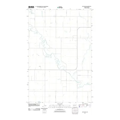
2011 Map of Kloten SE
USGS Topo · Published 2011About this map
The Sheyenne River defines the landscape of this Griggs County region, its winding path carving through the North Dakota prairie. In the northwest corner, the river expands into the southern reaches of Lake Ashtabula, a significant water feature that shapes the local hydrology. This 2011 survey illustrates a sparse, agrarian settlement pattern dominated by a strict grid of section roads, including 114th Ave NE and 7th St NE, which facilitate movement across the agricultural expanse. Aside from the BW Ranch, the map shows very little modern structural development, preserving the open character of the plains. Water management and drainage are central to the area's geography, evidenced by the meandering course of Pickerel Lake Creek as it feeds into the larger river system near County Hwy-10.
Find a feature on this map
17 named features on this map. Tap any name to fly to it.
Don’t see what you’re looking for? This feature index may not catch every label — zoom into the map to look around manually.
Map Details
Editions of this 2011 Kloten SE Map
This is the sole edition of this map. No revisions or reprints were ever made.
Other maps of this area

1952 · Grand Forks
USGS Topo · 1:250,000

1952 · New Rockford
USGS Topo · 1:250,000

1956 · New Rockford
USGS Topo · 1:250,000

1956 · Grand Forks
USGS Topo · 1:250,000

1961 · Kloten NW
USGS Topo · 1:24,000

1961 · Cooperstown East
USGS Topo · 1:24,000

1961 · Jessie
USGS Topo · 1:24,000

1961 · Cooperstown West
USGS Topo · 1:24,000

1966 · Grand Forks
USGS Topo · 1:250,000
1967 · Kloten SE
USGS Topo · 1:24,000