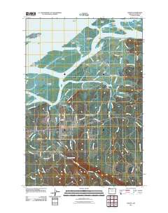
2011 Map of Knappa
USGS Topo · Published 2011About this map
Karlson Island and Marsh Island anchor a complex network of waterways where the Columbia River meets the intricate wetlands of Clatsop County. This landscape is defined by its sloughs and islands, including Horseshoe Island and Snag Islands, which created a challenging environment for early settlement. On the mainland, the communities of Knappa and Brownsmead are established along the edges of these tidal reaches, supported by infrastructure like the Tillusqua Fish Hatchery. The map documents a rural coastal economy tied to the water, visible through features like the Marsh Island Light and the numerous dikes, such as Brownsmead Dike Ln, protecting the low-lying valley lands. Local genealogy is grounded here at Maplewood Cemetery and Prairie Cemetery, while family-named roads like Maggie Johnson Rd and Hjalmer Anderson Rd speak to the area's homesteading history.
Find a feature on this map
75 named features on this map. Tap any name to fly to it.
Don’t see what you’re looking for? This feature index may not catch every label — zoom into the map to look around manually.
Map Details
Editions of this 2011 Knappa Map
This is the sole edition of this map. No revisions or reprints were ever made.
Other maps of this area

1940 · Svensen
USGS Topo · 1:62,500

1940 · Brookfield
USGS Topo · 1:62,500

1941 · Skamokawa
USGS Topo · 1:62,500

1941 · Cathlamet
USGS Topo · 1:62,500

1949 · Cathlamet Bay
USGS Topo · 1:24,000

1949 · Green Mountain
USGS Topo · 1:24,000

1949 · Rosburg
USGS Topo · 1:24,000

1953 · Hoquiam
USGS Topo · 1:250,000

1953 · Skamokawa
USGS Topo · 1:62,500

1953 · Cathlamet
USGS Topo · 1:62,500