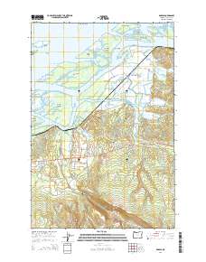
2014 Map of Knappa
USGS Topo · Published 2014About this map
The Columbia River dominates the northern reaches of this landscape, carving a complex network of islands and channels including Woody Island, Marsh Island, and Karlson Island. Near the water's edge, the settlement of Knappa serves as a focal point where the low-lying wetlands meet the rising timbered slopes of the coast range. The map details a unique amphibious geography where Marsh Island Light guides river traffic past Jim Crow Sands and the intricate bends of Devils Elbow.
Find a feature on this map
79 named features on this map. Tap any name to fly to it.
Don’t see what you’re looking for? This feature index may not catch every label — zoom into the map to look around manually.
Map Details
Editions of this 2014 Knappa Map
This is the sole edition of this map. No revisions or reprints were ever made.
Other maps of this area

1940 · Svensen
USGS Topo · 1:62,500

1940 · Brookfield
USGS Topo · 1:62,500

1941 · Skamokawa
USGS Topo · 1:62,500

1941 · Cathlamet
USGS Topo · 1:62,500

1949 · Cathlamet Bay
USGS Topo · 1:24,000

1949 · Green Mountain
USGS Topo · 1:24,000

1949 · Rosburg
USGS Topo · 1:24,000

1953 · Hoquiam
USGS Topo · 1:250,000

1953 · Skamokawa
USGS Topo · 1:62,500

1953 · Cathlamet
USGS Topo · 1:62,500