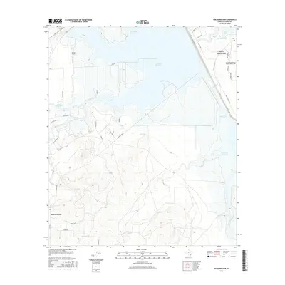
2016 Map of Knickerbocker
USGS Topo · Published 2016About this map
The South Concho River valley and the expansive waters of Twin Buttes Reservoir dominate this 2016 survey of the area southwest of San Angelo. The map details a landscape defined by significant water management and aviation infrastructure, including the Twin Buttes Dam and the nearby Lake Nasworthy. Aviation is prominent on the eastern edge of the quadrangle at the San Angelo Regional Airport/Mathis Field, while the smaller Ducote Airpark serves the north. Local history is anchored by the settlement of Knickerbocker in the southwest corner, positioned near the confluence of several drainages like Burks Cr. The terrain is marked by numerous small reservoirs and natural features such as Ketchum Spring, Xqz Lake, and Ripple Reservoir, illustrating the critical role of water sourcing in this portion of Tom Green County.
Find a feature on this map
37 named features on this map. Tap any name to fly to it.
Don’t see what you’re looking for? This feature index may not catch every label — zoom into the map to look around manually.
Map Details
Editions of this 2016 Knickerbocker Map
This is the sole edition of this map. No revisions or reprints were ever made.
Other maps of this area

1892 · San Angelo
USGS Topo · 1:125,000

1895 · Sherwood
USGS Topo · 1:125,000

1924 · San Angelo 2-c
USGS Topo · 1:48,000

1924 · Sherwood 1-d
USGS Topo · 1:48,000

1924 · San Angelo 2-b
USGS Topo · 1:48,000

1924 · Sherwood 1-a
USGS Topo · 1:48,000

1928 · Wall
USGS Topo · 1:62,500

1928 · Tankersly
USGS Topo · 1:62,500

1954 · San Angelo
USGS Topo · 1:250,000

1957 · Twin Buttes
USGS Topo · 1:24,000