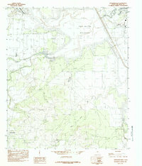
1984 Map of Knickerbocker
USGS Topo · Published 1984About this map
Knickerbocker and its surrounding ranch lands appear in this 1984 provisional survey, revealing a landscape defined by the confluence of West Texas water systems. The settlement is anchored by a local Cem, while the northern portion of the map is dominated by the massive reach of the Twin Buttes Reservoir. This artificial shoreline contrasts with the natural winding paths of the Middle Concho River, Dove Creek, and Burks Creek. Aviation and infrastructure are represented by Mathis Field and the edge of Lake Nasworthy to the northeast. Smaller, localized water sources like Ketchum Spr and Xqz Lake point to the critical importance of water management in Tom Green County. The topography is marked by numerous draws and plateaus, showing the intricate drainage patterns that feed into the Concho river system.
Find a feature on this map
15 named features on this map. Tap any name to fly to it.
Don’t see what you’re looking for? This feature index may not catch every label — zoom into the map to look around manually.
Map Details
Editions of this 1984 Knickerbocker Map
This is the sole edition of this map. No revisions or reprints were ever made.
Other maps of this area

1892 · San Angelo
USGS Topo · 1:125,000

1895 · Sherwood
USGS Topo · 1:125,000

1924 · San Angelo 2-c
USGS Topo · 1:48,000

1924 · Sherwood 1-d
USGS Topo · 1:48,000

1924 · San Angelo 2-b
USGS Topo · 1:48,000

1924 · Sherwood 1-a
USGS Topo · 1:48,000

1928 · Wall
USGS Topo · 1:62,500

1928 · Tankersly
USGS Topo · 1:62,500

1954 · San Angelo
USGS Topo · 1:250,000

1957 · Twin Buttes
USGS Topo · 1:24,000