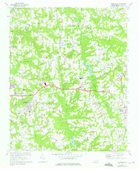
1967 Map of Knightdale
USGS Topo · Published 1975About this map
Knightdale and Wendell anchor this mid-1960s landscape, which shows the rural character of eastern Wake County before the rapid expansion of the Research Triangle region. The Norfolk Southern railway cuts a distinct line through the territory, connecting these rail-town centers and supporting the agricultural economy of the day. A 1973 photorevision, marked in purple, highlights the early growth of the regional infrastructure, including the Wendell-Knightdale Airport and several new residential developments and trailer parks.
Find a feature on this map
36 named features on this map. Tap any name to fly to it.
Don’t see what you’re looking for? This feature index may not catch every label — zoom into the map to look around manually.
Map Details
Editions of this 1967 Knightdale Map
4 editions found
Other maps of this area

1943 · Raleigh
USGS Topo · 1:62,500

1951 · Raleigh
USGS Topo · 1:62,500

1953 · Raleigh
USGS Topo · 1:250,000

1954 · Raleigh
USGS Topo · 1:250,000

1964 · Garner
USGS Topo · 1:24,000

1964 · Flowers
USGS Topo · 1:24,000

1964 · Selma
USGS Topo · 1:62,500

1964 · Clayton
USGS Topo · 1:24,000

1964 · Garner
USGS Topo · 1:62,500

1967 · Knightdale
USGS Topo · 1:24,000