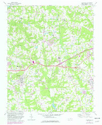
1967 Map of Knightdale
USGS Topo · Published 1982About this map
Knightdale and Wendell serve as the primary hubs in this eastern Wake County landscape, where the Norfolk Southern railway dictates the alignment of local commerce and settlement. The rural character of the mid-20th century is preserved in a network of community landmarks, from small country churches like Bethany Ch and Hephzibah Ch to local education centers such as Whitley High Sch. The terrain is defined by the drainage of Beaverdam Creek and Buffalo Creek, which feed into local water bodies including Lake Myra and Perry Pond. Cultural markers range from the curiously named Lizard Lick to the early aviation infrastructure of the Wendell-Knightdale Airport. This survey provides a clear look at the intersection of traditional crossroads, such as Wake Crossroads and Malbys Crossroads, with the emerging transportation corridors of the post-war era.
Find a feature on this map
35 named features on this map. Tap any name to fly to it.
Don’t see what you’re looking for? This feature index may not catch every label — zoom into the map to look around manually.
Map Details
Editions of this 1967 Knightdale Map
4 editions found
Other maps of this area

1943 · Raleigh
USGS Topo · 1:62,500

1951 · Raleigh
USGS Topo · 1:62,500

1953 · Raleigh
USGS Topo · 1:250,000

1954 · Raleigh
USGS Topo · 1:250,000

1964 · Garner
USGS Topo · 1:24,000

1964 · Flowers
USGS Topo · 1:24,000

1964 · Selma
USGS Topo · 1:62,500

1964 · Clayton
USGS Topo · 1:24,000

1964 · Garner
USGS Topo · 1:62,500

1967 · Knightdale
USGS Topo · 1:24,000