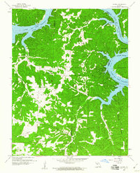
1959 Map of Knobby
USGS Topo · Published 1960About this map
Lake of the Ozarks dominates the northern and eastern reaches of this 1959 survey, where the Osage River winds through the deep hollows of Camden, Benton, and Morgan Counties. The map captures a rural landscape characterized by isolated settlements such as Lively, Sagrada, and the eponymous Knobby. Local navigation relies on a network of ridges and creeks, with landmarks like Duncans Point and Brown Bend marking the irregular shoreline created by the reservoir. Genealogists will find significant value in the distribution of family-named features and local gathering places. Notable interior sites include Walkers Corner, Pearson Branch Church, and Lick Creek Church, alongside the remote Adkins Cave and Cable Ridge Cemetery. The intricate drainages of Spring Valley Creek, Union Creek, and Jack Branch illustrate the dissected terrain that defined life in the Ozarks before modern development further altered the lakefront.
Find a feature on this map
46 named features on this map. Tap any name to fly to it.
Don’t see what you’re looking for? This feature index may not catch every label — zoom into the map to look around manually.
Map Details
Editions of this 1959 Knobby Map
2 editions found
Other maps of this area

1887 · Warsaw
USGS Topo · 1:125,000

1888 · Versailles
USGS Topo · 1:125,000

1893 · Versailles
USGS Topo · 1:125,000

1894 · Warsaw
USGS Topo · 1:125,000

1904 · Gravois Mills
USGS Topo · 1:62,500

1934 · Irontown Ferry
USGS Topo · 1:24,000

1935 · Barnumton
USGS Topo · 1:24,000

1935 · Proctor Creek
USGS Topo · 1:24,000

1935 · Edwards
USGS Topo · 1:24,000

1935 · Boylers Mill
USGS Topo · 1:24,000