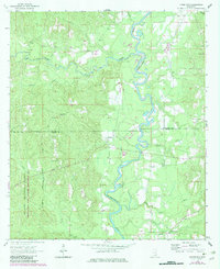
1964 Map of Knobtown
USGS Topo · Published 1982About this map
The Chickasawhay River meanders south through the pine-laden corridor of Wayne Co and Greene Co, its winding path defining the landscape as it was documented in the mid-1960s. This survey, with updates from the early 1980s, reveals a rural network of small communities and family-named landmarks like Kittrell and Knobtown. The presence of numerous remote cemeteries and churches, such as Slay Cem and Douglas Chapel, provides a roadmap for genealogists seeking to pin down family homesteads near the De Soto National Forest. The local economy of this era is etched into the terrain through various resource extraction sites, including a Tower and several Gravel Pits and Sandpits that dot the wooded elevations. These features, along with tributaries like Big Creek and Horse Creek, illustrate a quiet period of Mississippi history before significant modernization changed the rural character of the river valley.
Find a feature on this map
32 named features on this map. Tap any name to fly to it.
Don’t see what you’re looking for? This feature index may not catch every label — zoom into the map to look around manually.
Map Details
Editions of this 1964 Knobtown Map
3 editions found
Other maps of this area

1953 · Hattiesburg
USGS Topo · 1:250,000

1958 · Hattiesburg
USGS Topo · 1:250,000

1964 · Knobtown
USGS Topo · 1:24,000

1964 · Clark
USGS Topo · 1:24,000

1964 · Clara
USGS Topo · 1:24,000

1964 · Buckatunna
USGS Topo · 1:24,000

1964 · Avera
USGS Topo · 1:24,000

1964 · Piave
USGS Topo · 1:24,000

1974 · Fruitdale
USGS Topo · 1:24,000

1974 · State Line
USGS Topo · 1:24,000