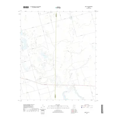
2019 Map of Knott SW
USGS Topo · Published 2019About this map
Knott Cem sits at the northern edge of this West Texas landscape, marking a point of interest for genealogists and local historians tracking family roots in the Permian Basin region. The terrain is defined by the ephemeral hydrology of the Llano Estacado, where Sulphur Springs Draw and Buzzard Draw carve low-relief paths across the prairie. The presence of Red Lake and numerous smaller depressions highlights the unique playa lake system characteristic of this high plains environment.
Find a feature on this map
26 named features on this map. Tap any name to fly to it.
Don’t see what you’re looking for? This feature index may not catch every label — zoom into the map to look around manually.
Map Details
Editions of this 2019 Knott SW Map
This is the sole edition of this map. No revisions or reprints were ever made.
Other maps of this area

1941 · Morita
USGS Topo · 1:62,500

1949 · Morita
USGS Topo · 1:62,500

1954 · Big Spring
USGS Topo · 1:250,000

1958 · Big Spring
USGS Topo · 1:250,000

1966 · Knott
USGS Topo · 1:24,000

1966 · Merrick
USGS Topo · 1:24,000

1966 · Natural Dam Lake
USGS Topo · 1:24,000

1966 · Knott SE
USGS Topo · 1:24,000
1966 · Elbow
USGS Topo · 1:24,000

1966 · Stanton
USGS Topo · 1:24,000