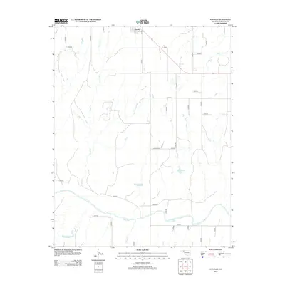
2012 Map of Knowles
USGS Topo · Published 2012About this map
Knowles sits at the northern edge of this Panhandle landscape, where the grid of Beaver County roads meets the winding path of the Beaver River. The river corridor dominates the southern portion of the sheet, supported by a network of drainage systems including Kidds Cr and Mexico Cr. This 2012 survey illustrates the importance of water management in the region, evidenced by numerous named storage sites such as Barby Number 3 Reservoir and Barby Number 18 Reservoir. The town itself is compactly organized around 3rd St, 4th St, and Jay Ave, serving as a central hub for the surrounding agricultural sections. The intersection of local routes like N1570 Rd and E0110 Rd highlights the traditional section-line survey pattern that defines the rural Oklahoma high plains.
Find a feature on this map
44 named features on this map. Tap any name to fly to it.
Don’t see what you’re looking for? This feature index may not catch every label — zoom into the map to look around manually.
Map Details
Editions of this 2012 Knowles Map
This is the sole edition of this map. No revisions or reprints were ever made.
Other maps of this area

1954 · Perryton
USGS Topo · 1:250,000

1958 · Perryton
USGS Topo · 1:250,000

1970 · Knowles
USGS Topo · 1:24,000

1970 · Gate
USGS Topo · 1:24,000
1970 · Gate NE
USGS Topo · 1:24,000

1970 · Gate NW
USGS Topo · 1:24,000

1970 · Mocane SE
USGS Topo · 1:24,000
1970 · Mocane
USGS Topo · 1:24,000

1971 · Clear Lake
USGS Topo · 1:24,000

1971 · Logan NW
USGS Topo · 1:24,000