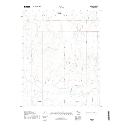
2018 Map of Knowles
USGS Topo · Published 2018About this map
Knowles serves as the primary settlement in this high plains landscape of the Oklahoma Panhandle, situated along the northern edge of the survey area. The terrain is defined by the meandering course of the Beaver River, which flows through the southern portion of the region, flanked by several smaller tributaries including Kidds Creek and Mexico Creek. The map documents a system of water management essential to the local environment, featuring a series of numbered impoundments such as Barby Number 3 Reservoir, Barby Number 18 Reservoir, and Barby Number 5 Reservoir. A rigorous grid of section lines and range roads, including Ew 10 and NS 158, organizes the open country around these riparian corridors and drainage channels like W Fork Horse Cr, illustrating the structured land division characteristic of Beaver County.
Find a feature on this map
53 named features on this map. Tap any name to fly to it.
Don’t see what you’re looking for? This feature index may not catch every label — zoom into the map to look around manually.
Map Details
Editions of this 2018 Knowles Map
This is the sole edition of this map. No revisions or reprints were ever made.
Other maps of this area

1954 · Perryton
USGS Topo · 1:250,000

1958 · Perryton
USGS Topo · 1:250,000

1970 · Knowles
USGS Topo · 1:24,000

1970 · Gate
USGS Topo · 1:24,000
1970 · Gate NE
USGS Topo · 1:24,000

1970 · Gate NW
USGS Topo · 1:24,000

1970 · Mocane SE
USGS Topo · 1:24,000
1970 · Mocane
USGS Topo · 1:24,000

1971 · Clear Lake
USGS Topo · 1:24,000

1971 · Logan NW
USGS Topo · 1:24,000