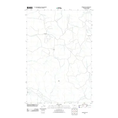
2011 Map of Knowlton
USGS Topo · Published 2011About this map
Knowlton and its surrounding ranchlands in Custer County are defined by a complex network of seasonal drainages and high plains terrain. This 2011 survey illustrates a sparse settlement pattern characteristic of eastern Montana, where the small community is centered near the convergence of Long Prong Locate Creek and North Fork Horse Creek. Genealogists and local historians can find the Knowlton Cemetery located south of the main townsite, serving as a primary landmark for the area's residents. Further south, the Gilman Ranch sits near the headwaters of Sheep Creek and Cedar Creek, illustrating the continued importance of large-scale ranching operations. The landscape is punctuated by geological features such as White Knob and the winding path of North Fork Sheep Creek, which cuts through the southern portion of the quadrangle.
Find a feature on this map
16 named features on this map. Tap any name to fly to it.
Don’t see what you’re looking for? This feature index may not catch every label — zoom into the map to look around manually.
Map Details
Editions of this 2011 Knowlton Map
This is the sole edition of this map. No revisions or reprints were ever made.
Other maps of this area

1953 · Miles City
USGS Topo · 1:250,000

1957 · Miles City
USGS Topo · 1:250,000

1958 · Miles City
USGS Topo · 1:250,000

1969 · Knowlton
USGS Topo · 1:24,000

1969 · Hogan Creek
USGS Topo · 1:24,000

1969 · Tepee Butte NE
USGS Topo · 1:24,000

1969 · Montague Butte
USGS Topo · 1:24,000
1969 · Pennock Creek
USGS Topo · 1:24,000
1969 · Red Knob
USGS Topo · 1:24,000
1980 · Miles City
USGS Topo · 1:100,000