
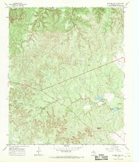
1967 Map of Knox City NW
USGS Topo · Published 1970About this map
The Brazos River carves a winding path through this corner of the Rolling Plains in the late 1960s, a landscape defined by its rugged drainages and emerging petroleum industry. The small settlement of Hamilton sits near the crossing of a major Pipeline and Mc Faddin Lane, surrounded by a network of seasonal waterways including Gyp Creek and Little Croton Creek. The map documents the geological and industrial character of the region during this era, showing numerous Oil Wells scattered across the northern sections and Gravel Pits concentrated near the riverbanks. As the terrain transitions toward the agricultural fields in the south, the confluence of Union Creek and a natural Spring provide vital water resources in this semi-arid Texas environment. The survey also captures complex jurisdictional boundaries where King, Knox, Stonewall, and Haskell counties meet.
Find a feature on this map
18 named features on this map. Tap any name to fly to it.
Don’t see what you’re looking for? This feature index may not catch every label — zoom into the map to look around manually.
Map Details
Editions of this 1967 Knox City NW Map
This is the sole edition of this map. No revisions or reprints were ever made.
Other maps of this area

1954 · Lubbock
USGS Topo · 1:250,000

1954 · Wichita Falls
USGS Topo · 1:250,000

1958 · Wichita Falls
USGS Topo · 1:250,000

1962 · Kiowa Peak
USGS Topo · 1:24,000

1965 · Jud
USGS Topo · 1:24,000

1967 · Cedar Mountain
USGS Topo · 1:24,000

1967 · Benjamin
USGS Topo · 1:24,000

1967 · Rochester
USGS Topo · 1:24,000

1967 · Kiowa Peak NE
USGS Topo · 1:24,000
1967 · Buzzard Peak
USGS Topo · 1:24,000