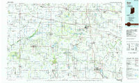
1984 Map of Knox
USGS Topo · Published 1985About this map
The Kankakee River and Yellow River define the drainage of this Northern Indiana landscape, where extensive wetlands and state-managed lands dominate the western half. Significant protected areas including the Kankakee State Game Preserve and Winamac State Fish and Game Area are visible, reflecting the region's commitment to conservation within its glacial plains. To the east, larger bodies of water like Lake Maxinkuckee and Lake Manitou serve as major focal points for local geography and recreation.
Find a feature on this map
117 named features on this map. Tap any name to fly to it.
Don’t see what you’re looking for? This feature index may not catch every label — zoom into the map to look around manually.
Map Details
Editions of this 1984 Knox Map
2 editions found
Other maps of this area

1934 · Porter
USGS Topo · 1:48,000

1940 · Porter
USGS Topo · 1:62,500

1953 · Wanatah
USGS Topo · 1:24,000

1953 · Westville
USGS Topo · 1:24,000

1953 · Valparaiso
USGS Topo · 1:24,000

1953 · Chesterton
USGS Topo · 1:24,000

1953 · Kouts
USGS Topo · 1:24,000

1953 · Fort Wayne
USGS Topo · 1:250,000

1953 · Chicago
USGS Topo · 1:250,000

1953 · Danville
USGS Topo · 1:250,000