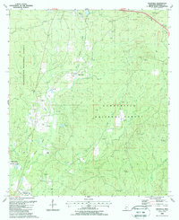
1988 Map of Knoxville
USGS Topo · Published 1988About this map
The Homochitto National Forest encompasses much of this southwestern Mississippi landscape, where the Illinois Central Gulf Railroad cuts a path through a terrain defined by complex drainages like Wells Creek and Tony Creek. This 1988 map documents the region's mid-century economic shift, showing a proliferation of energy infrastructure including the Dry Creek Oil Field, Knoxville Tower Oil Field, and Wesley Chapel Oil Field scattered among the timberlands. Small, rural settlements such as White Apple and Knoxville remain as local anchors, while dozens of family-named landmarks like McMillan Cem, Dorsey Cem, and Aldridge Cem provide critical data for genealogists tracing local lineage. The presence of established churches like Union Ch and Springhill Ch suggests a persistent community structure despite the encroachment of industrial oil exploration and the expansion of federal forest lands.
Find a feature on this map
45 named features on this map. Tap any name to fly to it.
Don’t see what you’re looking for? This feature index may not catch every label — zoom into the map to look around manually.
Map Details
Editions of this 1988 Knoxville Map
This is the sole edition of this map. No revisions or reprints were ever made.
Other maps of this area

1953 · Natchez
USGS Topo · 1:250,000

1956 · Natchez
USGS Topo · 1:250,000

1959 · Natchez
USGS Topo · 1:250,000

1961 · Crosby
USGS Topo · 1:62,500

1962 · Fayette
USGS Topo · 1:62,500

1962 · Bude
USGS Topo · 1:62,500

1963 · Union Church
USGS Topo · 1:62,500
1984 · Natchez
USGS Topo · 1:100,000

1984 · Brookhaven
USGS Topo · 1:100,000

1984 · McComb
USGS Topo · 1:100,000