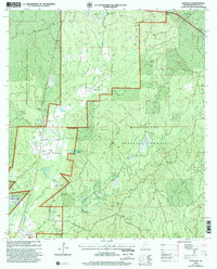
2000 Map of Knoxville
USGS Topo · Published 2002About this map
Homochitto National Forest dominates this landscape in Franklin County, defining a region where timbered terrain and resource extraction define the local economy. The map reveals a high density of industrial development through numerous sites like the North Knoxville Oil Field, Dry Creek Oil Field, and Richardson Creek Oil Field, which are interspersed among small rural settlements and homesteads.
Find a feature on this map
63 named features on this map. Tap any name to fly to it.
Don’t see what you’re looking for? This feature index may not catch every label — zoom into the map to look around manually.
Map Details
Editions of this 2000 Knoxville Map
This is the sole edition of this map. No revisions or reprints were ever made.
Other maps of this area

1953 · Natchez
USGS Topo · 1:250,000

1956 · Natchez
USGS Topo · 1:250,000

1959 · Natchez
USGS Topo · 1:250,000

1961 · Crosby
USGS Topo · 1:62,500

1962 · Fayette
USGS Topo · 1:62,500

1962 · Bude
USGS Topo · 1:62,500

1963 · Union Church
USGS Topo · 1:62,500
1984 · Natchez
USGS Topo · 1:100,000

1984 · Brookhaven
USGS Topo · 1:100,000

1984 · McComb
USGS Topo · 1:100,000