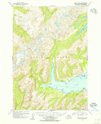
1954 Map of Kodiak B-4
USGS Topo · Published 1955About this map
Kiliuda Bay dominates the southern reaches of this interior portion of Kodiak Island, revealing a coastline defined by intricate points and sheltered waters. Entirely situated within the Kodiak National Wildlife Refuge, the landscape is characterized by high-elevation terrain featuring numerous unnamed peaks and glacial features. Surveyors identified several distinctive landmarks along the bay's shoreline, including Coxcomb Pt, Pivot Pt, and the low-lying areas of Green and Rain.
Find a feature on this map
12 named features on this map. Tap any name to fly to it.
Don’t see what you’re looking for? This feature index may not catch every label — zoom into the map to look around manually.
Map Details
Editions of this 1954 Kodiak B-4 Map
This is the sole edition of this map. No revisions or reprints were ever made.
Other maps of this area

1949 · Kodiak A-3
USGS Topo · 1:63,360

1949 · Kodiak B-3
USGS Topo · 1:63,360

1950 · Kodiak A-3
USGS Topo · 1:63,360

1950 · Kodiak B-3
USGS Topo · 1:63,360

1952 · Kodiak
USGS Topo · 1:250,000

1952 · Kodiak C-3
USGS Topo · 1:63,360

1952 · Kodiak C-4
USGS Topo · 1:63,360

1952 · Kodiak C-5
USGS Topo · 1:63,360

1952 · Kodiak B-5
USGS Topo · 1:63,360

1952 · Kodiak B-4
USGS Topo · 1:63,360