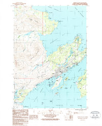
1987 Map of Kodiak D-2 SE
USGS Topo · Published 1988About this map
Kodiak serves as the focal point of this coastal study, situated along the complex shoreline of St Paul Harbor and Kodiak Harbor. The map reveals the intricate water management and aviation infrastructure essential to the island, from the Pillar Creek Reservoir and Lower Reservoir to the Municipal Airport and the larger Kodiak Airport further south. The landscape is dominated by significant elevations such as Pillar Mountain and the Devils Prongs, which overlook the urban center and its maritime facilities.
Find a feature on this map
73 named features on this map. Tap any name to fly to it.
Don’t see what you’re looking for? This feature index may not catch every label — zoom into the map to look around manually.
Map Details
Editions of this 1987 Kodiak D-2 SE Map
2 editions found
Other maps of this area

1949 · Kodiak C-2
USGS Topo · 1:63,360

1949 · Kodiak D-2
USGS Topo · 1:63,360

1949 · Kodiak C-1
USGS Topo · 1:63,360

1949 · Kodiak D-1
USGS Topo · 1:63,360

1951 · Kodiak D-1
USGS Topo · 1:63,360

1951 · Kodiak D-2
USGS Topo · 1:63,360

1951 · Kodiak C-1
USGS Topo · 1:63,360

1952 · Kodiak
USGS Topo · 1:250,000
1987 · Kodiak D-1 SW
USGS Topo · 1:25,000
1987 · Kodiak C-2 NW
USGS Topo · 1:25,000