
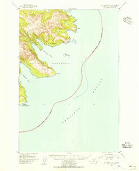
1951 Map of Kodiak D-6
USGS Topo · Published 1966About this map
Shelikof Strait meets the northwestern coast of Kodiak Island in this mid-century survey, revealing a landscape defined by sharp coastal points and interior alpine lakes. The coastline is marked by prominent landmarks such as Miners Pt and Cape Ugat, which provided essential navigational references for vessels traversing the strait. A lone Cabin near the northern shore represents the sparse human imprint on this remote terrain, while most of the land falls within the Kodiak National Wildlife Refuge.
Find a feature on this map
17 named features on this map. Tap any name to fly to it.
Don’t see what you’re looking for? This feature index may not catch every label — zoom into the map to look around manually.
Map Details
Editions of this 1951 Kodiak D-6 Map
This is the sole edition of this map. No revisions or reprints were ever made.
Other maps of this area

1948 · Mt Katmai
USGS Topo · 1:250,000

1951 · Mt Katmai
USGS Topo · 1:250,000

1951 · Karluk
USGS Topo · 1:250,000
1951 · Mount Katmai A-1
USGS Topo · 1:63,360

1952 · Kodiak
USGS Topo · 1:250,000

1952 · Afognak
USGS Topo · 1:250,000

1952 · Karluk
USGS Topo · 1:250,000

1952 · Kodiak C-5
USGS Topo · 1:63,360

1952 · Kodiak D-5
USGS Topo · 1:63,360

1952 · Karluk C-1
USGS Topo · 1:63,360