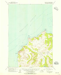
1954 Map of Kodiak D-6
USGS Topo · Published 1955About this map
Shelikof Strait borders the western coastline of Kodiak Island in this mid-century topographic study, which highlights a landscape almost entirely comprised of the Kodiak National Wildlife Refuge. The terrain is defined by prominent coastal landmarks such as Miners Pt, Cape Ugat, and Twocone Pt, where scattered cabins suggest seasonal activity or remote outposts. In the interior, significant freshwater bodies like Spiridon Lake and Little River Lake feed the Little River, which winds through the steep elevations of Saddle Mtn. The survey provides a clear view of the island's coastline and interior waterways before modern infrastructure reached this corner of the Alaska-Third Judicial Division, offering researchers a look at the region’s topography as it was documented in the early 1950s.
Find a feature on this map
14 named features on this map. Tap any name to fly to it.
Don’t see what you’re looking for? This feature index may not catch every label — zoom into the map to look around manually.
Map Details
Editions of this 1954 Kodiak D-6 Map
This is the sole edition of this map. No revisions or reprints were ever made.
Other maps of this area

1948 · Mt Katmai
USGS Topo · 1:250,000

1951 · Mt Katmai
USGS Topo · 1:250,000

1951 · Karluk
USGS Topo · 1:250,000
1951 · Mount Katmai A-1
USGS Topo · 1:63,360

1951 · Kodiak D-6
USGS Topo · 1:63,360

1952 · Kodiak
USGS Topo · 1:250,000

1952 · Afognak
USGS Topo · 1:250,000

1952 · Karluk
USGS Topo · 1:250,000

1952 · Kodiak C-5
USGS Topo · 1:63,360

1952 · Kodiak D-5
USGS Topo · 1:63,360