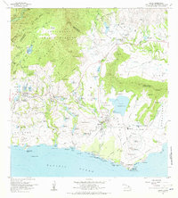
1963 Map of Koloa
USGS Topo · Published 1971About this map
Sugar production and coastal development define this southern Kauai landscape during the early 1960s. The massive Waita Reservoir and a complex network of smaller upland impoundments like Alexander Reservoir and Mau Res feed the irrigation needs of the Lihue and Koloa districts. Industrial activity centers on the Koloa Mill and its adjacent Koloa Mill Airstrip, while the shoreline transition is evident at Koloa Landing and the burgeoning area of Poipu.
Find a feature on this map
117 named features on this map. Tap any name to fly to it.
Don’t see what you’re looking for? This feature index may not catch every label — zoom into the map to look around manually.
Map Details
Editions of this 1963 Koloa Map
2 editions found
Other maps of this area

1954 · Kauai
USGS Topo · 1:250,000

1963 · Lihue
USGS Topo · 1:24,000

1963 · Hanapepe
USGS Topo · 1:24,000

1963 · Kapaa
USGS Topo · 1:24,000

1963 · Koloa
USGS Topo · 1:24,000

1965 · Waimea Canyon
USGS Topo · 1:24,000

1965 · Waialeale
USGS Topo · 1:24,000

1967 · Kauai
USGS Topo · 1:250,000

1970 · Kauai
USGS Topo · 1:250,000
1977 · Hanapepe
USGS Topo · 1:24,000