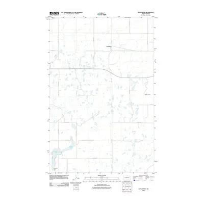
2011 Map of Kongsberg
USGS Topo · Published 2011About this map
Kongsberg sits at a transition between the northern prairie flats and the more varied terrain found near the prominent Dogden Butte to the southeast. This McHenry County landscape is defined by its glacial prairie potholes, with numerous small unnamed water bodies scattered throughout the sections. The southern portion of the sheet is anchored by Strawberry Lake and its associated Strawberry Lake Dam, as well as the nearby Camp Lake. A network of rural section roads, including 10th Ave NW and County Hwy 27, connects the small settlement of Kongsberg to the surrounding agricultural land. The terrain data reflects the quiet, rural character of this North Dakota region before significant modern development, focusing on the essential water resources and topography that dictated the placement of farms and small hubs.
Find a feature on this map
22 named features on this map. Tap any name to fly to it.
Don’t see what you’re looking for? This feature index may not catch every label — zoom into the map to look around manually.
Map Details
Editions of this 2011 Kongsberg Map
This is the sole edition of this map. No revisions or reprints were ever made.
Other maps of this area

1929 · Kongsberg
USGS Topo · 1:62,500

1929 · Balfour
USGS Topo · 1:62,500

1945 · Pelican Lake
USGS Topo · 1:62,500

1947 · Pelican Lake
USGS Topo · 1:62,500

1947 · Turtle Lake
USGS Topo · 1:62,500

1954 · McClusky
USGS Topo · 1:250,000

1958 · McClusky
USGS Topo · 1:250,000

1958 · Butte
USGS Topo · 1:24,000
1958 · Kongsberg NE
USGS Topo · 1:24,000
1958 · Balfour NW
USGS Topo · 1:24,000