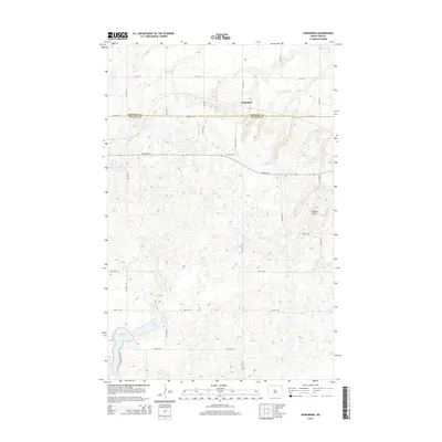
2014 Map of Kongsberg
USGS Topo · Published 2014About this map
Kongsberg sits at the intersection of prairie topography and the administrative boundary separating McHenry and McLean counties. This landscape is defined by the prominent Dogden Butte, which rises above a complex network of glacial potholes and wetlands. To the south, the terrain transitions into a concentrated lake district featuring Camp Lake and Strawberry Lake. These water bodies, along with smaller unnamed seasonal basins, historically supported local recreation and agricultural drainage. The presence of Severson S Resort along the southern lakeshore highlights the area's role as a local destination for outdoor leisure. A structured grid of section-line roads, including 29th St NW and 31st St N, facilitates movement across this agricultural and wetland mosaic, reflecting the enduring legacy of the Public Land Survey System in North Dakota's rural development.
Find a feature on this map
13 named features on this map. Tap any name to fly to it.
Don’t see what you’re looking for? This feature index may not catch every label — zoom into the map to look around manually.
Map Details
Editions of this 2014 Kongsberg Map
This is the sole edition of this map. No revisions or reprints were ever made.
Other maps of this area

1929 · Kongsberg
USGS Topo · 1:62,500

1929 · Balfour
USGS Topo · 1:62,500

1945 · Pelican Lake
USGS Topo · 1:62,500

1947 · Pelican Lake
USGS Topo · 1:62,500

1947 · Turtle Lake
USGS Topo · 1:62,500

1954 · McClusky
USGS Topo · 1:250,000

1958 · McClusky
USGS Topo · 1:250,000

1958 · Butte
USGS Topo · 1:24,000
1958 · Kongsberg NE
USGS Topo · 1:24,000
1958 · Balfour NW
USGS Topo · 1:24,000