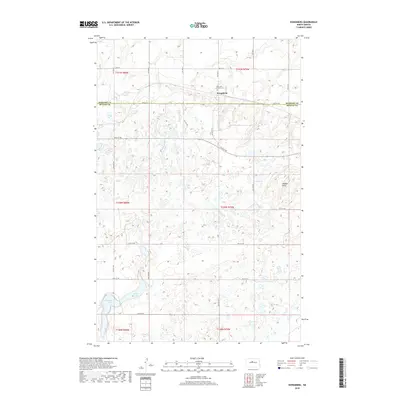
2018 Map of Kongsberg
USGS Topo · Published 2018About this map
Kongsberg sits at the junction of McHenry and McLean counties, characterized by a complex glacial landscape of prairie potholes and scattered wetlands. The settlement is anchored by the Saint John Lutheran Cem, serving as a significant landmark for local family historians and genealogists. To the south, the terrain descends toward Strawberry Lake, while the prominent elevation of Dogden Butte rises in the eastern portion of the quadrangle. The map details a rectilinear grid of rural roads, including 30th St NW and 25th St NW, which reflect the persistent township and range organization of this agricultural region. This survey captures the rural character of the North Dakota plains, where small community hubs and natural features like Camp 36 Lake define the social and physical geography.
Find a feature on this map
20 named features on this map. Tap any name to fly to it.
Don’t see what you’re looking for? This feature index may not catch every label — zoom into the map to look around manually.
Map Details
Editions of this 2018 Kongsberg Map
This is the sole edition of this map. No revisions or reprints were ever made.
Other maps of this area

1929 · Kongsberg
USGS Topo · 1:62,500

1929 · Balfour
USGS Topo · 1:62,500

1945 · Pelican Lake
USGS Topo · 1:62,500

1947 · Pelican Lake
USGS Topo · 1:62,500

1947 · Turtle Lake
USGS Topo · 1:62,500

1954 · McClusky
USGS Topo · 1:250,000

1958 · McClusky
USGS Topo · 1:250,000

1958 · Butte
USGS Topo · 1:24,000
1958 · Kongsberg NE
USGS Topo · 1:24,000
1958 · Balfour NW
USGS Topo · 1:24,000