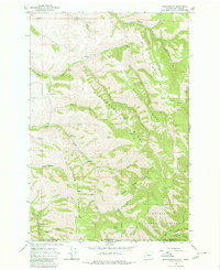
1966 Map of Kooskooskie
USGS Topo · Published 1980About this map
The settlement of Kooskooskie sits at the base of the Blue Mountains along the Railroad and Mill Creek, marking a point of transition where the Washington and Oregon state line intersects the Umatilla National Forest. This 1966 field-checked survey reveals a landscape of prominent high-altitude features like Blacksnake Ridge, Biscuit Ridge, and Klicker Mountain. The drainage patterns are intricate, with Blue Creek and its many tributaries, including Little Blue Creek, cutting through deep canyons such as Nightingale Canyon. Local landmarks like the Kiwanis Camp and Stewart Cabin suggest the area's use for recreation and seasonal residence, while a small Cem and the Five Points junction provide specific points of interest for genealogists tracing local families. The presence of a Gaging Sta and Dam near the main settlement indicates the importance of water management for the downstream Walla Walla Valley.
Find a feature on this map
36 named features on this map. Tap any name to fly to it.
Don’t see what you’re looking for? This feature index may not catch every label — zoom into the map to look around manually.
Map Details
Editions of this 1966 Kooskooskie Map
Other maps of this area

1919 · Walla Walla
USGS Topo · 1:125,000

1921 · Walla Walla
USGS Topo · 1:125,000

1937 · Pomeroy
USGS Topo · 1:96,000

1942 · Pomeroy
USGS Topo · 1:125,000

1953 · Pendleton
USGS Topo · 1:250,000

1953 · Walla Walla
USGS Topo · 1:250,000

1955 · Pullman
USGS Topo · 1:250,000

1955 · Grangeville
USGS Topo · 1:250,000

1956 · Pendleton
USGS Topo · 1:250,000

1958 · Pullman
USGS Topo · 1:250,000