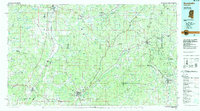
1984 Map of Kosciusko
USGS Topo · Published 1985About this map
The Big Black River and Yockanookany River carve through the heart of central Mississippi on this 1980s-era survey, where the Natchez Trace Parkway follows the ancient path across Attala Co and Choctaw Co. The landscape is a network of small timber-and-agricultural settlements linked by the Illinois Central Gulf railroad, which connects the regional hubs of Winona and Durant in the west to Ackerman and Louisville in the east. This edition captures the rural character of the region before modern highway expansions, showing localized industries like Sandpits and a Claypit near Stewart. Significant conservation lands including the Tombigbee National Forest and Jeff Busby Park provide a clear view of the preserved wilderness areas that define the region's topography between the river bottoms and uplands like Arnold Mountain.
Find a feature on this map
86 named features on this map. Tap any name to fly to it.
Don’t see what you’re looking for? This feature index may not catch every label — zoom into the map to look around manually.
Map Details
Editions of this 1984 Kosciusko Map
3 editions found

Other maps of this area

1936 · Greenwood
USGS Topo · 1:62,500

1940 · Seven Pines
USGS Topo · 1:62,500

1940 · Lexington
USGS Topo · 1:62,500

1940 · Greenwood
USGS Topo · 1:62,500

1953 · Walthall
USGS Topo · 1:62,500

1953 · Meridian
USGS Topo · 1:250,000

1953 · Greenwood
USGS Topo · 1:250,000

1953 · West Point
USGS Topo · 1:250,000

1954 · Duck Hill
USGS Topo · 1:62,500

1954 · McCarley
USGS Topo · 1:62,500