
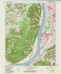
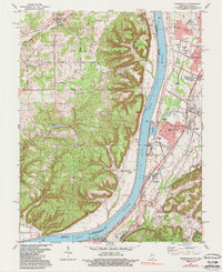
1981 Map of Kosmosdale
USGS Topo · Published 1994About this map
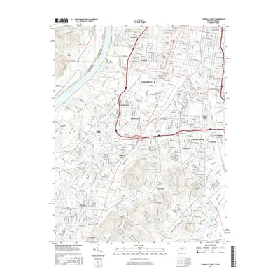
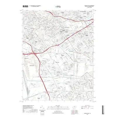
The Ohio River carves through the center of this landscape, separating the elevated, ridge-crossed terrain of Posey and Taylor in Indiana from the industrial and residential growth of Jefferson County. Along the Kentucky bank, the Illinois Central Gulf railroad supports a corridor of industry including a massive Powerplant and an Industrial Waste Pond near Kosmosdale. This 1980s-era revision shows the transition from dense woodland at McHarry Hill to the suburban expansion at Valley Station and Valley Gardens. Small rural enclaves such as Happy Hollow and Macedonia persist among the valleys, while the Fort Knox Military Reservation occupies the southern reaches near the confluence of the Salt River. Genealogical interest is found in numerous family and community sites like Mill Creek Cem and Moore Chapel, which highlight the area's long-established riverfront settlement history.
Find a feature on this map
74 named features on this map. Tap any name to fly to it.
Don’t see what you’re looking for? This feature index may not catch every label — zoom into the map to look around manually.
Map Details
Editions of this 1981 Kosmosdale Map
3 editions found
Historical Maps of Louisville Through Time
48 maps found

1909 Kosmosdale
Jefferson County, KY

1912 Kosmosdale
Jefferson County, KY

1950 Kosmosdale
Jefferson County, KY

1951 Fisherville
Jefferson County, KY

1951 Louisville East
Jefferson County, KY

1951 Valley Station
Jefferson County, KY

1953 Madison East
Jefferson County, KY

1955 Louisville East
Jefferson County, KY

1955 Louisville West
Jefferson County, KY

1955 Valley Station
Jefferson County, KY

1960 Fisherville
Jefferson County, KY

1960 Louisville East
Jefferson County, KY

1960 Louisville West
Jefferson County, KY

1960 Valley Station
Jefferson County, KY

1965 Louisville East
Jefferson County, KY

1965 Louisville West
Jefferson County, KY
1981 Kosmosdale
Jefferson County, KY

1982 Fisherville
Jefferson County, KY

1982 Louisville East
Jefferson County, KY

1982 Valley Station
Jefferson County, KY

1983 Louisville West
Jefferson County, KY

1993 Valley Station
Jefferson County, KY

1998 Louisville West
Jefferson County, KY

2010 Fisherville
Jefferson County, KY

2010 Louisville East
Jefferson County, KY

2010 Louisville West
Jefferson County, KY

2010 Valley Station
Jefferson County, KY

2011 Kosmosdale
Jefferson County, KY

2013 Fisherville
Jefferson County, KY

2013 Kosmosdale
Jefferson County, KY

2013 Louisville East
Jefferson County, KY
2013 Louisville West
Jefferson County, KY

2013 Valley Station
Jefferson County, KY
2016 Fisherville
Jefferson County, KY

2016 Kosmosdale
Jefferson County, KY

2016 Louisville East
Jefferson County, KY
2016 Louisville West
Jefferson County, KY
2016 Valley Station
Jefferson County, KY
2019 Fisherville
Jefferson County, KY
2019 Kosmosdale
Jefferson County, KY
2019 Louisville East
Jefferson County, KY

2019 Louisville West
Jefferson County, KY
2019 Valley Station
Jefferson County, KY

2022 Fisherville
Jefferson County, KY

2022 Kosmosdale
Jefferson County, KY

2022 Louisville East
Jefferson County, KY

2022 Louisville West
Jefferson County, KY

2022 Valley Station
Jefferson County, KY