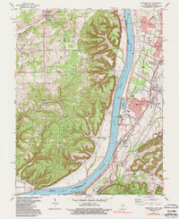
1981 Map of Kosmosdale
USGS Topo · Published 1988About this map
The Ohio River carves a deep valley between the ridges of Posey County, Indiana, and the growing suburban and industrial landscape of southwest Jefferson County, Kentucky. This 1981 survey documents the era of industrial expansion along the riverbanks, where massive infrastructure like the powerplant, substations, and a long conveyor system serve the river-to-rail transit corridor. To the south, the Fort Knox Military Reservation encroaches on the hills, while the Illinois Central Gulf Railroad and Louisville and Nashville Railroad provide the backbone for local commerce. Genealogists will find a wealth of local landmarks, from the Colvin Cem and Mill Creek Cem to rural outposts like Elizabeth Ch and the many schools, including Watson Lane Sch and Frost Middle Sch, that anchored these communities before modern development reshaped the region.
Find a feature on this map
93 named features on this map. Tap any name to fly to it.
Don’t see what you’re looking for? This feature index may not catch every label — zoom into the map to look around manually.
Map Details
Editions of this 1981 Kosmosdale Map
3 editions found
Other maps of this area

1909 · Kosmosdale
USGS Topo · 1:48,000

1912 · Kosmosdale
USGS Topo · 1:62,500

1931 · Corydon
USGS Topo · 1:62,500

1936 · Vine Grove
USGS Topo · 1:62,500

1941 · Ekron
USGS Topo · 1:62,500

1943 · Vine Grove
USGS Topo · 1:62,500

1946 · Rock Haven
USGS Topo · 1:24,000

1946 · Pitts Point
USGS Topo · 1:24,000

1946 · Fort Knox
USGS Topo · 1:24,000

1946 · Vine Grove
USGS Topo · 1:62,500