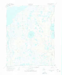
1950 Map of Kotzebue B-6
USGS Topo · Published 1975About this map
White Fish Lake centers this coastal landscape of the Seward Peninsula, appearing as it was documented by photogrammetric methods just after the mid-century. The terrain is a complex network of tundra waterways and thermokarst features, bounded to the north by the Arctic Ocean. The drainage patterns are defined by the meandering Cowpack River and the parallel flows of the Singoakpuk River, Kalik River, and Kiliuk River, which move through an area largely devoid of permanent settlements or roads. Rising above the low-lying wetlands, Devil Mountain and the associated Devil Mountain Lakes provide significant topographic relief in the eastern portion of the quadrangle. Geodetic control points like VABM Devil 706 and VABM Simnuk 127 provide precise reference markers for early surveyors navigating this remote coastal reach.
Find a feature on this map
12 named features on this map. Tap any name to fly to it.
Don’t see what you’re looking for? This feature index may not catch every label — zoom into the map to look around manually.
Map Details
Editions of this 1950 Kotzebue B-6 Map
2 editions found
Other maps of this area

1950 · Kotzebue C-6
USGS Topo · 1:63,360

1950 · Shishmaref
USGS Topo · 1:250,000
1950 · Kotzebue C-5
USGS Topo · 1:63,360

1950 · Shishmaref A-1
USGS Topo · 1:63,360

1950 · Kotzebue A-6
USGS Topo · 1:63,360

1950 · Shishmaref B-1
USGS Topo · 1:63,360

1950 · Kotzebue B-5
USGS Topo · 1:63,360

1950 · Kotzebue B-6
USGS Topo · 1:63,360

1950 · Kotzebue A-5
USGS Topo · 1:63,360

1951 · Shishmaref
USGS Topo · 1:250,000