
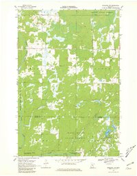
1968 Map of Kroschel NW
USGS Topo · Published 1970About this map
The Snake River carves a winding path through this region of the Aitkin and Kanabec county border, defining a landscape dominated by conservation and timber management. In the late 1960s, large tracts of land were dedicated to state-managed resources, including the Solana State Forest in the north and the Snake River State Forest in the south. These public lands are interspersed with specialized conservation zones like the Lake Five State Wildlife Management Area and the Bean Dam State Wildlife Management Area. The map reveals a sparsely settled interior where the economy is tied to natural resources, evidenced by a Gravel Pit and numerous watercourses like Cowans Brook and Chelsea Brook. Subtle human imprints such as a Radio Tower and various Jeep Trails offer clues to the communication and transport networks used by forestry workers and local outdoorsmen during this era.
Find a feature on this map
24 named features on this map. Tap any name to fly to it.
Don’t see what you’re looking for? This feature index may not catch every label — zoom into the map to look around manually.
Map Details
Editions of this 1968 Kroschel NW Map
2 editions found
Other maps of this area

1953 · Duluth
USGS Topo · 1:250,000

1958 · Duluth
USGS Topo · 1:250,000

1968 · Pomroy Lake
USGS Topo · 1:24,000

1968 · Warman
USGS Topo · 1:24,000

1968 · Giese
USGS Topo · 1:24,000
1968 · Kroschel
USGS Topo · 1:24,000

1968 · Mc Grath
USGS Topo · 1:24,000

1969 · Solana
USGS Topo · 1:24,000

1969 · Arthyde
USGS Topo · 1:24,000

1969 · Thor SE
USGS Topo · 1:24,000