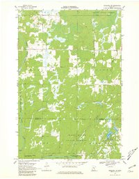
1968 Map of Kroschel NW
USGS Topo · Published 1981About this map
Snake River meanders through a landscape defined by extensive conservation and wildlife management lands along the Aitkin Co Kanabec Co line. The terrain is characterized by numerous marshy lowlands and water bodies like Lake Five and Long Lake, supporting several dedicated preserves including the Hay-Snake State Wildlife Management Area and Bean Dam State Wildlife Management Area. Human activity in the late 1960s is concentrated on a sparse grid of roads and a few industrial markers such as a Radio Tower and Gravel Pit sites. Large portions of the territory are managed as the Solana State Forest and Snake River State Forest, where a simple Jeep Trail provides the primary access into the wooded sections. Small drainage systems like Cowans Brook and Chelsey Brook feed the river, which remains the central geographical feature of this largely undeveloped northwoods region.
Find a feature on this map
23 named features on this map. Tap any name to fly to it.
Don’t see what you’re looking for? This feature index may not catch every label — zoom into the map to look around manually.
Map Details
Editions of this 1968 Kroschel NW Map
2 editions found
Other maps of this area

1953 · Duluth
USGS Topo · 1:250,000

1958 · Duluth
USGS Topo · 1:250,000

1968 · Kroschel NW
USGS Topo · 1:24,000

1968 · Pomroy Lake
USGS Topo · 1:24,000

1968 · Warman
USGS Topo · 1:24,000

1968 · Giese
USGS Topo · 1:24,000
1968 · Kroschel
USGS Topo · 1:24,000

1968 · Mc Grath
USGS Topo · 1:24,000

1969 · Solana
USGS Topo · 1:24,000

1969 · Arthyde
USGS Topo · 1:24,000