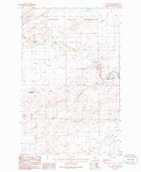
1985 Map of Kuka Crossing
USGS Topo · Published 1986About this map
Blackfeet Indian Reservation lands dominate the northern portion of this Pondera County study, defined by the winding course of Birch Creek and its broad Birch Creek Flats. The landscape is a network of drainage features and early irrigation efforts, including Miller Coulee, Cartwright Coulee, and the curiously named Sober Up Coulee. This mid-1980s provisional survey shows the transition from the high reservation plains to the managed water systems of the agricultural region to the south, evidenced by the B 4 Ditch. Small, isolated settlements and crossing points like Kingsbury Colony, Pierce Crossing, and the namesake Kuka Crossing serve as the primary human landmarks in a territory otherwise shaped by coulees and wide alluvial plains. The presence of several Gravel Pits and Sewage Disposal Ponds indicates localized industrial and infrastructural activity near the colony during this period.
Find a feature on this map
15 named features on this map. Tap any name to fly to it.
Don’t see what you’re looking for? This feature index may not catch every label — zoom into the map to look around manually.
Map Details
Editions of this 1985 Kuka Crossing Map
This is the sole edition of this map. No revisions or reprints were ever made.
Other maps of this area

1914 · Heart Butte
USGS Topo · 1:125,000

1918 · Heart Butte
USGS Topo · 1:125,000

1920 · Dupuyer
USGS Topo · 1:125,000

1934 · Lake Frances
USGS Topo · 1:48,000

1936 · Pendroy
USGS Topo · 1:48,000

1937 · Lake Frances
USGS Topo · 1:62,500

1941 · Pendroy
USGS Topo · 1:62,500

1960 · Cut Bank
USGS Topo · 1:250,000

1963 · Cut Bank
USGS Topo · 1:250,000

1964 · Cut Bank
USGS Topo · 1:250,000
Featured Places
- Pierce Crossing, MT
- Aubrey Crossing, MT
- Kingsbury Hutterite Colony, MT
- Kuka Crossing, MT
- Pondera Colony, MT