1954 Map of Kuskokwim Bay D-4
USGS Topo · Published 1971About this map
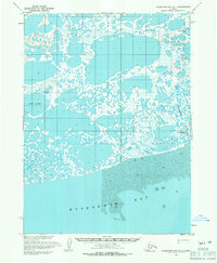
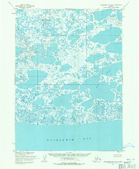
Kwigillingok sits at the edge of the Kuskokwim Bay coastline, serving as a primary settlement in this low-lying delta landscape during the mid-1950s. The map illustrates a complex network of thermokarst lakes and tidal channels, where the Kwigillingok River winds through vast stretches of mudflats and marsh. Small outposts and named locations like Anogok and Snare are visible, alongside a local Cem, providing evidence of historical habitation in this challenging environment. Large water bodies such as Bow Lake and Kolekfikpuk Lake dominate the interior, surrounded by unnamed ponds that characterize the permafrost-influenced terrain. This survey, compiled from aerial photographs by the U. S. Army Topographic Command, captures the intricate transition from land to sea before the shoreline and hydrologic patterns shifted in the following decades.
Find a feature on this map
9 named features on this map. Tap any name to fly to it.
Don’t see what you’re looking for? This feature index may not catch every label — zoom into the map to look around manually.
Map Details
Editions of this 1954 Kuskokwim Bay D-4 Map
2 editions found

Other maps of this area

1951 · Kuskokwim Bay
USGS Topo · 1:250,000

1951 · Baird Inlet
USGS Topo · 1:250,000
1954 · Baird Inlet A-5
USGS Topo · 1:63,360
1954 · Baird Inlet A-3
USGS Topo · 1:63,360

1954 · Baird Inlet
USGS Topo · 1:250,000
1954 · Kuskokwim Bay
USGS Topo · 1:250,000

1954 · Kuskokwim Bay D-3
USGS Topo · 1:63,360
1954 · Kuskokwim Bay D-5
USGS Topo · 1:63,360
1954 · Baird Inlet A-4
USGS Topo · 1:63,360

2020 · Baird Inlet A-4 SE
USGS Topo · 1:25,000