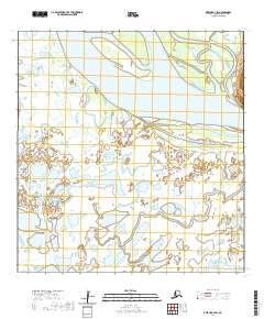
2020 Map of Kwiguk A-4 SW
USGS Topo · Published 2020About this map
The Yukon River dominates this portion of the Kusilvak Census Area, carved by a network of interconnected waterways and shifting riverine islands. This landscape of the Yukon-Kuskokwim Delta is defined by the heavy braiding of the main channel and the entrance of the Archuelinguk River from the northeast. In the southern reaches of the map, the Kipungolak River meanders through a dense wetland complex of ponds and sloughs. While mostly devoid of built settlements, the presence of Spring Water Road along the eastern bank of the Yukon indicates a rare point of overland transit in a region almost entirely dependent on water-based movement. The intricate patterns of hydrography shown here reflect the natural state of the lower Yukon drainage system as it appeared in the early 21st century.
Find a feature on this map
10 named features on this map. Tap any name to fly to it.
Don’t see what you’re looking for? This feature index may not catch every label — zoom into the map to look around manually.
Map Details
Editions of this 2020 Kwiguk A-4 SW Map
This is the sole edition of this map. No revisions or reprints were ever made.
Other maps of this area

1951 · Marshall
USGS Topo · 1:250,000

1952 · Kwiguk
USGS Topo · 1:250,000

1952 · Kwiguk A-5
USGS Topo · 1:63,360

1952 · Kwiguk A-4
USGS Topo · 1:63,360

1952 · Marshall D-5
USGS Topo · 1:63,360

1952 · Marshall D-6
USGS Topo · 1:63,360

1954 · Marshall
USGS Topo · 1:250,000
2020 · Marshall D-6 NE
USGS Topo · 1:25,000
2020 · Kwiguk A-4 NE
USGS Topo · 1:25,000
2020 · Kwiguk A-4 SE
USGS Topo · 1:25,000