
1952 Map of Marshall D-6
USGS Topo · Published 1964About this map
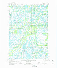
Kashunuk River meanders through a vast network of wetlands and tundra in this early 1950s survey of the Seward Meridian. The landscape is dominated by complex water systems, where the river loops back upon itself amidst countless unnamed ponds and sloughs. Near the southwestern corner, the settlement of Owl Village stands as a rare point of human habitation in this remote region. Compiled by the Army Map Service using photogrammetric methods from aerial photography taken in 1951 and 1952, the map documents a terrain that was largely unsurveyed and unmarked on the ground at the time. This record provides a clear look at the natural drainage patterns of the Alaskan wilderness before more modern environmental shifts, centered on the Kashunuk River corridor.
Find a feature on this map
2 named features on this map. Tap any name to fly to it.
Don’t see what you’re looking for? This feature index may not catch every label — zoom into the map to look around manually.
Map Details
Editions of this 1952 Marshall D-6 Map
2 editions found
Other maps of this area

1951 · Marshall
USGS Topo · 1:250,000

1952 · Kwiguk
USGS Topo · 1:250,000

1952 · Kwiguk A-5
USGS Topo · 1:63,360

1952 · Kwiguk A-4
USGS Topo · 1:63,360

1952 · Marshall D-5
USGS Topo · 1:63,360

1952 · Marshall C-7
USGS Topo · 1:63,360

1952 · Marshall C-6
USGS Topo · 1:63,360

1952 · Marshall C-5
USGS Topo · 1:63,360
1952 · Marshall D-7
USGS Topo · 1:63,360

1954 · Marshall
USGS Topo · 1:250,000