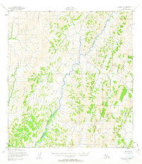
1952 Map of Kwiguk D-1
USGS Topo · Published 1963About this map
The Andreafsky River dominates this 1952 topographic study, winding its way through the intricate drainage patterns of the western Alaska interior. This map is a record of an unsurveyed landscape, where land lines and boundaries were predetermined by the Bureau of Land Management rather than marked on the ground. The detailed contouring, derived from 1951 aerial photography by the Army Map Service, reveals the complex hydrology of the region, including the headwaters of the Nunakogok River. This era of mapping represents a transition in Alaskan survey history, utilizing photogrammetric methods to chart territory that remained largely inaccessible to ground crews. The map serves as a vital document for understanding the natural geography of the Seward Meridian Boundary area before modern development or environmental shifts altered these remote waterways.
Find a feature on this map
3 named features on this map. Tap any name to fly to it.
Don’t see what you’re looking for? This feature index may not catch every label — zoom into the map to look around manually.
Map Details
Editions of this 1952 Kwiguk D-1 Map
2 editions found
Other maps of this area

1951 · Unalakleet
USGS Topo · 1:250,000

1951 · St Michael
USGS Topo · 1:250,000

1951 · Holy Cross
USGS Topo · 1:250,000

1952 · Kwiguk
USGS Topo · 1:250,000

1952 · Kwiguk D-1
USGS Topo · 1:63,360

1952 · Kwiguk C-2
USGS Topo · 1:63,360

1952 · Kwiguk D-2
USGS Topo · 1:63,360

1952 · Saint Michael A-1
USGS Topo · 1:63,360

1952 · Saint Michael A-2
USGS Topo · 1:63,360

1952 · Holy Cross C-6
USGS Topo · 1:63,360