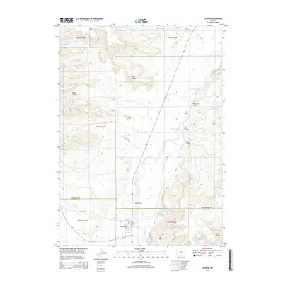
2015 Map of La Barge
USGS Topo · Published 2015About this map
La Barge sits at the southern edge of this survey where the high desert terrain meets the flowing Green River. The town grid, defined by streets like La Barge St and Main St, serves as a hub for the surrounding ranching and resource lands of Lincoln Co and Sublette Co. The landscape is dominated by complex topographical features, including the aptly named Bird Nipple, The Frog, and the prominent Little Mesa to the north. Transport through this high country relies on the Us-189 corridor and the Whelan Bridge, which provides a vital crossing over the Green River near the junction of several canyon systems. Deep drainages such as Wildcat Canyon and Figure Four Canyon carve through the tablelands, illustrating the erosive power of seasonal water across this arid Wyoming stretch. The map documents the intricate network of secondary roads like Birch Creek Rd and Green River Bend Rd that connect isolated landmarks like Red Hill to the valley floor.
Find a feature on this map
37 named features on this map. Tap any name to fly to it.
Don’t see what you’re looking for? This feature index may not catch every label — zoom into the map to look around manually.
Map Details
Editions of this 2015 La Barge Map
This is the sole edition of this map. No revisions or reprints were ever made.
Other maps of this area

1945 · Fort Hill
USGS Topo · 1:62,500

1947 · Fort Hill
USGS Topo · 1:62,500

1955 · Preston
USGS Topo · 1:250,000

1958 · Preston
USGS Topo · 1:250,000

1962 · Preston
USGS Topo · 1:250,000

1968 · Anderson Canyon
USGS Topo · 1:24,000

1968 · Names Hill
USGS Topo · 1:24,000

1969 · Chimney Butte
USGS Topo · 1:24,000

1969 · La Barge
USGS Topo · 1:24,000
1969 · Milleson Draw
USGS Topo · 1:24,000